Google Maps for Mobile‘s My Location feature works in the Sony Ericsson K850i, the latest in the Cyber-shot line to hit the market. My Location is a cool feature that places your approximate location on the map using GPS (Global Positioning System) or mobile towers.
If you have one of the recent phones that report cell sites, Google Maps will draw a blue circle on the map to represent your approximate location, as determined through the use of cell sites.
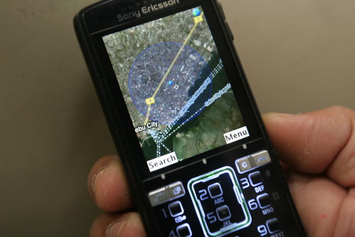 WHERE AM I? Anywhere from Fuente Osmneña to the middle of the Cebu harbor, according to this location data provided by Google Maps for Mobile running in the Sony Ericsson K850i. I was inside the Sun.Star Cebu office on P de. Rosario St. when I ran the application. Click on photo to enlarge image.
I previously tried the service with the K750i and K800i but both units don’t report cell sites they are using to connect to the network My Location won’t work with them. Last week, I tried it with a K850i demo unit lent to me by Sony Ericsson Philippines for testing and got it working in no time.
I used my Smart account in testing the K850i so its cell towers were the ones being used to plot the phone’s location.
It isn’t GPS, which is accurate up to a few meters, and the blue circle that indicates my general location covers an area that seems more than a kilometer wide.
While eating my usual after-midnight dinner in Chowking on the highway in Mandaue City near the San Miguel plant, My Location drew a circle that would have placed my general location as far apart as the intersection in Wireless, the area near the Cebu International Convention Center and right before the old Mactan-Mandaue bridge.
When I tried My Location in Lapu-Lapu City, near the two intersections that have recently become cesspools near Mactan Doctors’ Hospital, Google Maps said I was somewhere in Taguig City. Imagine that. Sitio Kagudoy, Taguig City. I don’t now how Google Maps gets geographical data on the cell sites but it got this one really wrong.
When I tried Google Maps at the Sun.Star Cebu office on P. del Rosario St., I was given a general location that, according to the software, was within 1,700 meters. It’s a pretty large area (check the photo).
I asked my wife to locate me using Smart’s Person Finder service and the service said I was “near Sacred Heart Church, D. Jakosalem St, Bgy. Cogon Ramos, Cebu City.” It’s pretty much the same wide area.
Do I hear a collective male sigh of relief? You can be looking at hookers on Junquera St. and the system will say you’re near a church.
The area used to be smaller. I remember being reported as somewhere near University of San Carlos when I was inside Sun.Star Cebu. Maybe cellphone towers have become stronger and gotten wider coverage that they are now farther apart.
Using Google Maps for Mobile with the K850i and my Smart account was such a joy in a geeky sort of way. But unless you’re a frequent traveler, you won’t find much use of it. My daily commute is such a routine I could probably tell you what size of potholes are in which part of the the main highway connecting Cebu City to Mandaue City and Lapu-Lapu City.
Max is a journalist and blogger based in Cebu. He has written and edited for such publications as The Freeman, The Independent Post, Today, Sun.Star Cebu, Cebu Daily News, Philstar Life, Esquire Philippines, and Rappler. Max is an Aries Rufo Journalism Fellow for 2024.
He is also a mobile app and web developer and co-founded InnoPub Media.
Leave a Reply